Tuesday, June 22, 2010

Real-Time London Tube Map - Updated

Live London Underground Map

This is one occasion when the screenshot really doesn't do a map any favours. Imagine the image above but with all the red map markers moving. Actually, don't imagine it, click on the link and view the map for real.

This Google Map shows in real-time the location and movement of London Underground trains. I actually live next to a London Underground line and I've been able to check the accuracy of the map by looking out my window to see if the trains are where the map says they are. Overall it seems amazingly accurate.

The yellow markers show the location of Underground stations. The animated red markers (the trains) can be clicked on to see which line they are on, which station they are approaching and when they will arrive. Great fun!

Live Line

Live Line is taking the same Transport for London data and using it to show the real-time position of Underground trains without a map. Instead Live Line uses colour-coded horizontal lines with station markers (see screenshot).

The numbers on the lines show the position of the trains. The numbers move in real-time to show the trains' current positions. Seeing this visualisation of TfL data makes me think that it is only a matter of time before someone produces a Harry Beck designed Underground Map with live trains.

Hat-tip: @tomcoates

________________

Free Data Sets for Google Maps

Koordinates

Koordinates is a great resource to get free geographical data sets from around the world. Koordinates allows you to download various kinds of geographic or GIS data. Some of the data is commercial and requires payment before it can be downloaded however the majority of the geographical layers seem to be free.

The site uses Google Maps to allow you to browse geographical layers on a map before you download them. The layers can also be viewed by category, by country / region and by 'most popular' and 'recently added'.

Koordinates seems to be based in New Zealand and has a huge amount of data available for the country. However the site also seems to have a large number of geographical layers for the United States and sporadic coverage elsewhere.

Via: Mapperz

________________

Monday, June 21, 2010

Measuring Distance with Google Maps

Distance Measurement Tool

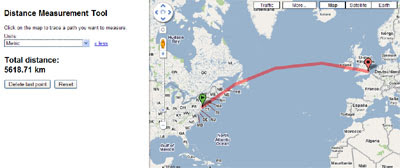
Google Maps Labs has a new distance measurement tool. If you select the tool from Google Maps a small ruler will be added to the bottom of the map next to the distance scale.

If you click on the ruler tool you can then measure the distance between any two points on the Earth by clicking on the map. If you want to measure further you can carry on clicking on the map to add further points.

The map comes with an 'I feel geeky' option that allows you to change the measurement units. There are a large number of measurement units available, including Olympic swimming pool lengths and American football pitches alongside the more traditional units such as kilometres and miles.

The Distance Measurement Tool also works with the Google Earth view in Google Maps.

Hat-tip: Mapperz via Google Operating System

________________

Background Location Sharing on the iPhone

Loopt

Loopt has announced today that it will this week enable 'background location sharing' on its iPhone app thanks to new multi-tasking features in the Apple’s iOS 4. This means that users will be able to have Loopt running in the background and share their location with selected friends without having to specifically check in.

Loopt uses Google Maps to show you the real-time location of your friends. Loopt may also come with the option to share your location only at set times. The Loopt blog says "users choose which friends to include on the background location sharing updates, and how long to keep the location sharing turned on".

I take this to mean that Loopt will now have some form of time control. So you can select to share your location with different people only at select times of the day. For example, you could opt to share your location with your colleagues only during office hours.

The new 'background location sharing' means that Loopt can now push notifications to your iPhone when you have friends nearby, without you having to 'check-in'. It should also lead to a revolution in how location is shared in other iPhone applications.

Just wait for the thousands of companies releasing applications that will ping you when you are passing one of their stores. You may not want them but you can bet they are coming.

Via: ReadWriteWeb

________________

That New Orleans Sound on Google Maps

Open Sound New Orleans

The Open Sound New Orleans map is an amazing gateway to the wonderful music and sounds of New Orleans. It allows you to take a virtual walk around New Orleans, stop at the Cafe du Monde and listen to the amazing tunes of two street musicians. Alternatively you could head up to Mithra Street and catch a couple of rappers in action.

Open Sound New Orleans is a community media project that is getting New Orleanians to document their lives in sound. Participants are asked to record the important sounds and voices in their lives and add them to a Google Map of New Orleans sounds.

The project lends recording equipment, and offers training in its use, to community organisations, neighbourhood groups and individuals. The sounds recorded are then added to the map and can be shared, reused and adapted by others.

The sounds on the New Orleans sound map are categorised into 'ambient sounds', 'music sounds' and 'all voice sounds' and it is possible to view the map markers altogether or separately on the map.

Via: @geoparadigm

Other Sound Maps
________________

UK Freeview Reception on Google Maps

UK Free TV: Freeview Map

If you live in the UK and are considering getting the Freeview satellite TV service then you should check out this excellent Freeview Reception map.

To find out how good the Freeview reception is at your address just enter a postcode, national grid reference or a latitude and longitude. A Google Map of your location will then be displayed showing the television transmitters that you receive television from.

It is also possible to view the returned results by direction, received signal strength, by frequency, service name or transmitter name.

The yellow areas on the map show where the transmitter provides the best signal, the green area is where there is overlap and where the selected transmitter is not the strongest signal.

Via: Mapperz

________________

Sunday, June 20, 2010

Restaurant Bookmarking with Google Maps

The Chow Down

The Chow Down is a restaurant finding, bookmarking and sharing website.

You can use The Chow Down to find restaurants by type of food and by location, for example you can search for 'sushi' in 'San Francisco'. The results of a search are then shown in list form and their locations are shown on a static Google Map.

The name and address of each restaurant is displayed alongside its user rating. If you like the look of a restaurant you can bookmark it and the restaurant is added to your saved results. You can share your saved results via Twitter and you can even invite your friends to meet you at the restaurant.

________________

Blog Archive

 
Best Retirement Invesments